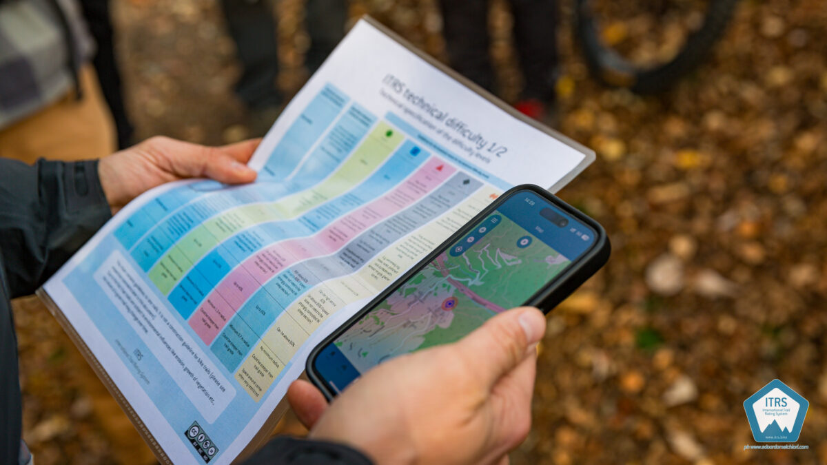
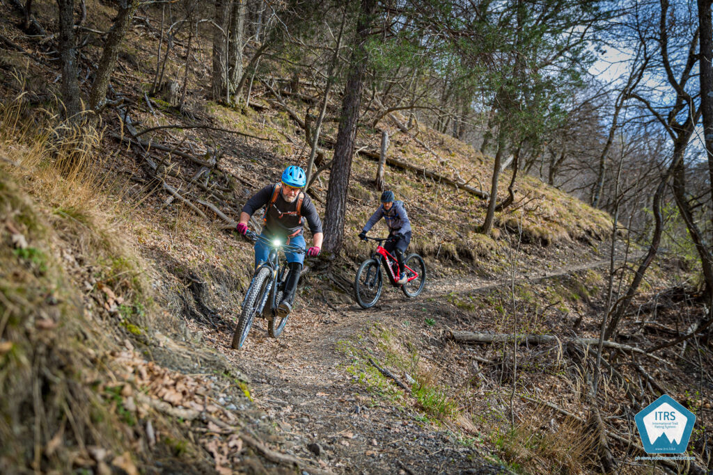
In early February 2025, we released a significant update to the ITRS on www.itrs.bike. If you are an active user of the ITRS, please download the updated materials and review the following article thoroughly.
This update introduces an enhanced signage concept that fully exploits the capabilities of the ITRS. Additionally, the descriptions of the criteria for determining technical difficulty have been expanded, and explanatory drawings have been included to aid in trail rating. Numerous smaller adjustments have been made based on the continuous feedback we receive, particularly during our trail rating training sessions. Furthermore, we have added the ITRS nutshell overview in Spanish.
Here’s what’s new and why.
1. Signage concept by infrastructure level leveraging the full potential of the ITRS
Although the ITRS does not specify guidelines on trail signposting, we have now established a comprehensive set of recommendations. These guidelines are based on practical field experience with various signage implementations, particularly in Garda Trentino, as well as other locations.
Version 5.0 of the ITRS contains recommendations for signs for each of the infrastructure levels:
- Route/tour
- Whole Trail
- Trail Segment
- Key section (short passages)
- Individual Feature (technical elements/TTFs)
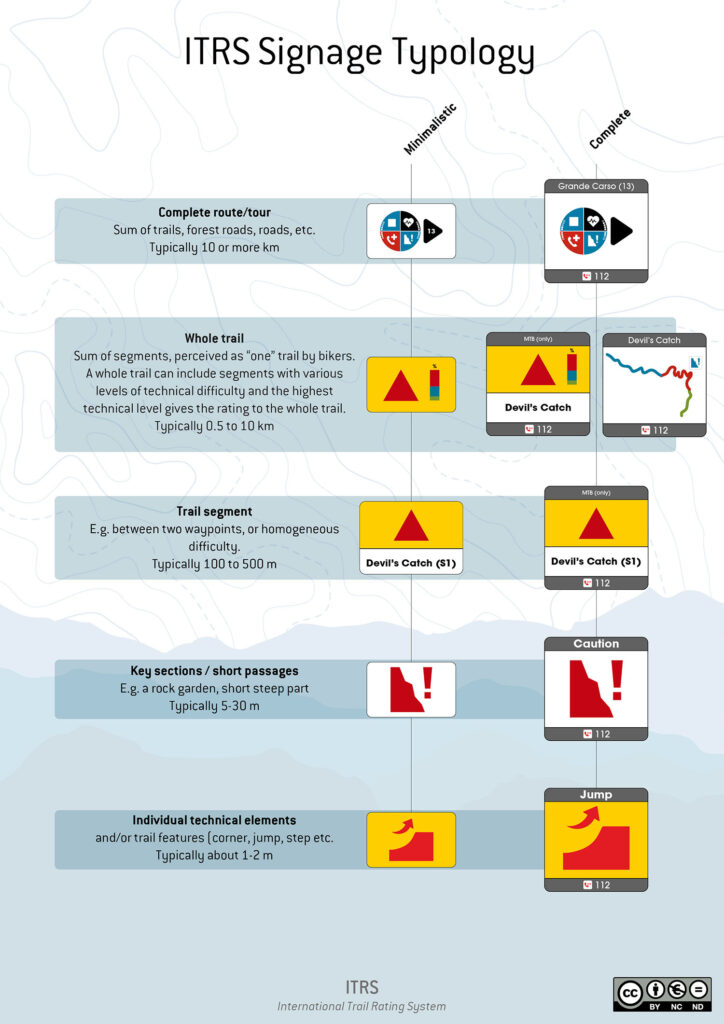
This structuring allows to use the information provided by the ITRS in various levels of detail that can be chosen according to local circumstances and target user groups.
- For routes, the use of the ITRS route pie is recommended if the budget allows. A similar signage concept for Garda Trentino’s 700+ km network received positive feedback. We offer various sign layouts, including a simplified version with a direction-indicating triangle next to the route pie. We also provide a less expensive alternative to the route pie signage.
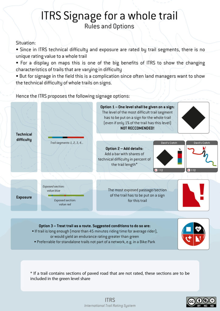
- For whole trails, an intuitive sign was created to indicate that a whole trail can include segments with different technical difficulties. The sign shows the highest difficulty level of the trail and the proportion of each difficulty level along the trail. This helps bikers quickly determine if the entire trail is challenging or just a short segment. Additionally, the highest level of exposure on the trail can be included on the sign.
- For trail segments, one can indicate the technical difficulty. This is useful for bike parks or when a segment with a higher technical level is included in a route with an overall lower technical level. Up to 5% of trails may exceed the route rating if the segments are shorter than 500 meters.
- For key sections, exposure can be indicated to inform users in advance that an exposed section is approaching.
- On the level of individual features on can, e.g., signpost different types of jumps or TTFs.
Examples were provided for the new signs, along with illustrations of how to use them in various combinations. The professional graphics package, available for download, also includes the new signs, so please be sure to download the updated package.
2. Technical Difficulty
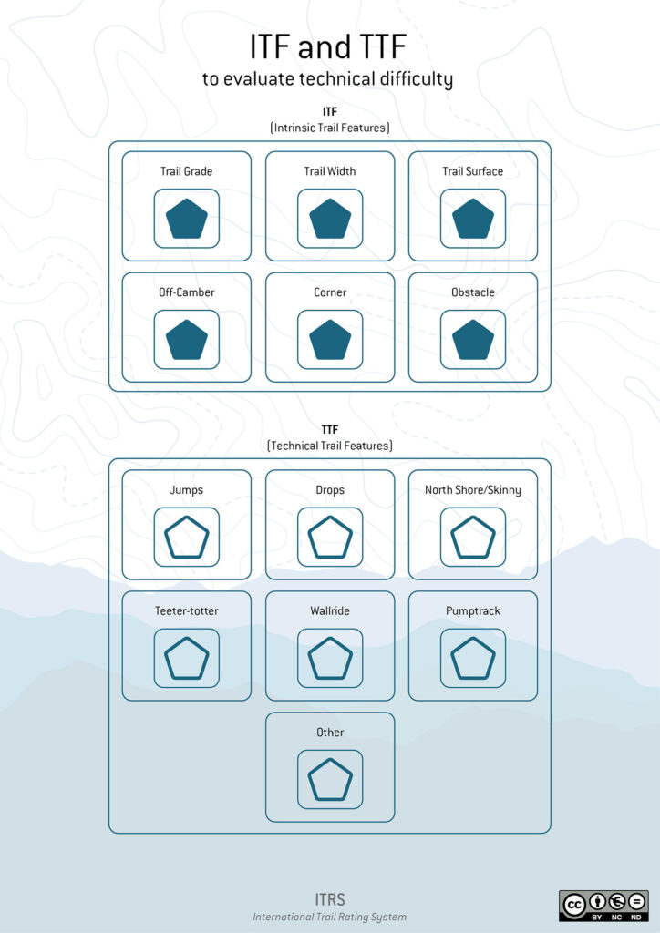
- Expanded description of the criteria to determine the technical difficulty
Based on the experiences with the ITRS Trail Rating app, the rating criteria are grouped into ITF – intrinsic trail features, and TTF – technical trail features. ITF are criteria that exist on any kind of trail. TTF are features that are only found on purpose-built bike trails. To rate a trail, all ITF need to be rated. TTF only need to be rated when they are present. For each of the ITF and TTF, an expanded description and drawings have been created. Explanations for why the ITF and TTF are defined that way in the ITRS are also included, which is based on the required riding skills. This expanded section is intended to help trail raters make informed decisions and is based on professional trail rater training experiences.
- Refinement and adjustment of technical trail specification
In general, all the below described adjustments do affect existing trail ratings only in a way that some trails may be rated as being easier than before. There are no changes that would require you to rate a trail as more difficult (compared to ITR Release 4.x).
The main goal is to put the different evaluation criteria even more into the context of the riding skills that are required to ride such sections.
- The values for the maximum grade and average grade were refined to partially steeper values.
- The effect of ruts/erosion channels and clearance for pedals and handlebar was newly structured.
- For Wallrides, measurable rating criteria are introduced. The rating is based on the inclination of the wall, the type of transition into and out of the wall, and how short the wall is, i.e. how sharp one has to turn at the highest point.
3. Wilderness
We added vending machines that operate 24/7 and are payable with coins and/or cards as drinking water sources that can be counted in the rating.
4. Various
- ITRS nutshell chart in Spanish added
- Updated description of the goals of the ITRS
For clearer communication, we added one overarching goal: “Making mountain biking more accessible, inclusive, safe, and enjoyable by consistently rated and communicated trails, globally and locally.” Next to the 3 existing partial goals of safety, quality, and adventure, it has been noted that ITRS also aims to create additional opportunities for trail professionals. - An additional page has been included that delineates the responsibilities of bikers. This section elucidates how the ITRS preserves the adventurous essence of mountain biking by empowering riders. The ITRS provides bikers with pertinent information, allowing them to make informed decisions regarding their rides. It outlines the specific information made available by the ITRS and the considerations and preparations that bikers should undertake, such as deciding whether to ride or walk an exposed section.
- Page added explaining special ITRS terminology and how it is related to the infrastructure levels.
This reflects the terminology used in the ITRS Trail Rating App, e.g., assessment points, ITF, exposure point, wilderness point, etc. - Comparison chart with different rating systems
Dutch system and system of Finale Outdoor Region added. Whole graphic refined with the respective system symbols.
2 replies on “ITRS 5.0 update with expanded signage concept”
Guten Tag,
ich fände es schön wenn die App auch Personen ohne Schulung zugänglich wäre. Viele haben nicht das entsprechende Geld übrig für die Ausbildung. Aber es werden trotzdem Trails eingestellt bei Trailforks oder OSM. Diese sind zum Teil komplett falsch bewertet. Mir hat es auch schon geholfen die Übersicht der verschiedenen Bewertungs Standards im Vergleich. Dadurch habe ich auch bei mir deutliche Falschbewertungen korrigiert. Danke
Es wäre auch schön die Dokumente in DE zu übersetzen.
Hallo Thomas
Vielen Dank für deinen Kommentar. Wir planen in der Tat, die ITRS Trail Rating App auch ohne Training zur Verfügung zu stellen. Das geht aber erst, wenn wir die Fertigstellung und den User-Support der App finanziert haben und sie kommerziell anbieten können. Im Moment bekommt man nur als Zertifizierter Trail Rater einen App-Testing-Account. Aber da sind wir dran.
Trails, die dann von nicht zertifizierten Ratern gerated werden mit der App, bekommen dann entsprechend in den Daten nicht das ITRS Trail Zertifikat. Dann ist allen ersichtlich, welche Ausbildungstufe hinter einem Rating steht.
Es freut uns natürlich, dass du bestätigst, dass das ITRS auch ohne die professionelle Ausbildung schon hilfreich ist für eine bessere Einstufung der Trails!
Uns ist bewusst, dass die Kosten für die Ausbildung zum Zertifizierten Trail Rater (CTR) nicht von jedem aufgebracht werden können. Diese Ausbildung dient dazu, dass die CTRs dann aus dem Raten von Trails ein Geschäftsmodell machen können. Wenn man ein solches sieht, lohnt sich die Investition in die Ausbildung, sonst natürlich weniger. Wir sind überzeugt, dass sich ein Markt entwickelt für professionell geratete Trails, aber wir wollen, wie von dir vorgeschlagen, natürlich auch alle anderen motivierten Personen mit einbeziehen.
Bzgl. der Übersetzung auf Deutsch wäre das natürlich toll. Wir stehen da vor der Herausforderung, dass wir zur Zeit ohne Fördergelder auskommen müssen, uns also komplett selber finanzieren. Da müssen wir unsere Ressourcen sehr gezielt einsetzen. Zudem veröffentlichen wir die regelmässigen Updates des Systems und des inzwischen 78 Seiten umfassenden Profi-Dokuments. Dieses in mehreren Sprachen up to date zu halten, ist eine Challenge. Da braucht es eine clevere technische Lösung. Uns ist das Thema bewusst, aber bei den begrentzen Ressourcen braucht es noch etwas Geduld, bis wir es angehen können. Wir beschränken uns im Moment darauf, den One-Pager zum ITRS in noch mehr Sprachen herauszubringen, damit die Übersetzung der Bezeichnungen der Schwierigkeitsgrade kontrolliert geschieht. Für den grossen Rest muss man sich im Moment mit Englisch oder KI-Übersetzungen zufrieden geben.
Für Unterstützungsvorschläge in diese Richtung sind wir natürlich immer offen!
Beste Grüsse aus dem Wallis!
Mischa